As
this forecast unfolded for several days
before this event, it seemed to get easier
to make the decision to chase the closer it
got. The weather models held pretty
solid and with Brian Stertz, our chase
partner's input, we put our faith in the
HRRR model to guide our way today.
That model showed the strongest storm of the
day would form in Missouri and head in the
direction of Springfield, IL. All
indications were that all of the better
tornado parameters pointed to this southern
end storm. We would find that the
model verified fairly well for both location
and times.
As
my son Ryan and I left the house around
12:00 noon, I originally had in mind a
target of Pittsfield, IL. In
traveling there, I chose to take Highway
61 north on the Missouri side of the
Mississippi River. That would allow
a westward alteration in the event that
things initiated further west than
anticipated. I figured we had a
river crossing a Louisiana, MO if we
needed it.
As we got to the highway at Bowling
Green to cut over the river to Illinois,
I decided to hold on the Missouri
side. Being we left plenty of time
early today, we figured we'd get some
lunch, look at data again, then decide
what course of action to take. I
kept going north on 61. Little did
I know that finding a place for lunch
was non-existent between there and
Hannibal, MO. Ended up going all
the way to Hannibal, MO and had lunch at
the Taco Bell.
After looking things over again, the
decision was made to stick to our original
plan with a potential southern storm
becoming the most dominant after things
unfolded around 4:00pm-5:00pm as per the
model, so we worked our way back to
Roodhouse, IL for our holding place.
As we
traveled, we began to see the very start of
the cumulus clouds beginning to bubble back
in Missouri. Our friend Nick Pavlovits
was back on the Missouri side of the river
giving us the update on those clouds.
About this time is when the early storms
took off in the far northeastern corner of
Missouri started becoming severe. Then
we got a call from our friend Jeff
Piotrowski letting us know that the clouds
just coming over the river to our southwest
were just starting to get their act
together. Our radar indicated they
were growing, albeit a bit slow.
We
navigated to a location a bit to the east to
get in proper alignment with the angle of
the storms that were now coming right at
us. As we got in position, we could
see the storms we thought were growing were
now vaporizing and a call from Piotrowski
again confirmed that fact. His advice,
get north to those storms heading for
Macomb, IL. So now we were faced with
a little over an hour of light left and
having storms already tornado warned to the
northwest 60 miles from us or seeing
virtually nothing and calling it a
day. Ryan wanted to go north to get to
the storms at dusk and I was more of the
mind set to minimize loses and call it a day
with the loss of daylight. Ryan won
that quick conversation and we headed north
toward the storms.
As we headed for the
northern storms going through Jacksonville,
IL, a very small updraft area began
developing just to the southwest again.
Certainly looked promising for a
second look. We ended up stopping and
watching it closely and noticed it was
growing quickly both visually and on the
radar.
The
race to the northern storms was now over as we
decided that this storm would either make it or
break it for us. As the storm grew and moved
toward us, we decided to work our way back to
Interstate 72 and work our way east ahead of the
storm. We moved east a couple of times and
stopped to take a few pictures, then would move
east again with the storm and stop for a few more
pictures. Finally with the last of the
light, we decided to stop and let the storm roll
toward us. We were looking back west at the
storm as it now began to produce a couple of
funnel clouds.
We were
so focused on the lowerings that we did not see the
hail core creep up on us. After a few "bangs" on
the car, we made a quick exit from our vantage point
and got east pronto. Drove several miles looking
for a shelter to duck under from the big, damaging
hail knowing it could get bigger.
Luckily, with ping-pong size hail
falling along with a few golf ball size hail
stones mixed in for good measure, we did not
lose a window in the car. We finally took
cover in a bank overhang in New Berlin, IL and
let the hail core pass us. We also had a
perfect view of the wall cloud and lowering as
it passed right in front of us as we looked
straight ahead out of the overhang.
As
the hail now came to an end, we exited the bank
overhang and now had the back end of the storm
right in front of us although now it was near
total darkness. Since we were no longer in
danger of large hail and needed to head east to
get to the Highway in Springfield, IL to head back
home, it was just a matter of following the
spinning wall cloud as we moved east. A bit
further down the road as we got closer to
Springfield, IL, we stopped for a few more
pictures/video.
We
noticed things were starting to change and
looked like it could drop a tornado.
As we moved once again, right in front of
us, a tornado roped down out of the
cloud. It
never fully condensed all of the
way to the ground, but a couple
of power flashes indicated the
tornado was firmly on the
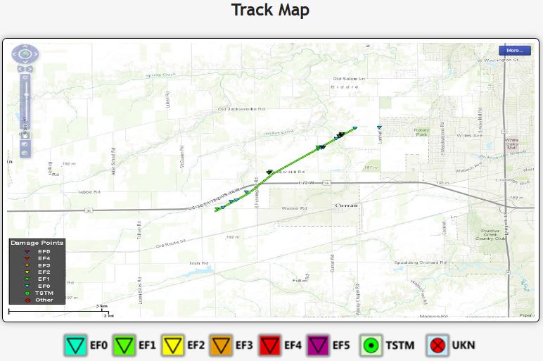
ground. Damage was later
confirmed by Piotrowski as he
did a survey later in the night.
Now
it was a matter of working our way around
Springfield. We hit Highway 4 around
the west side of Springfield, then Highway
29 around the north side. Got back
on Highway 54 with the storm once again in
front of us, but by this time, the tornado
warning had been dropped followed by the
severe warning. At this point, we
called it a day.
Special shout out to Jeff Piotrowski,
Brian Stertz, Nick Pavlovits, and Tyler
Schlitt for the updates throughout the
day's chase. Drove a lot of miles
today considering the tornado ended up
less than a 100 miles away from home.
National
Weather Service - Lincoln, IL
Click
Image to Enlarge
<>>
391 miles,
around 9.5 hours
|
Click
on the link below to see video of
some of these storms.
|
 March 15, 2016