Woke
up to a continuing string of low-end,
potential tornado day possibilities. My son
calls me mid-morning to ask me if I was for sure set
on not chasing this day. I said absolutely no way I could chase
today due to prior commitments. To
our northeast was a 5% tornado risk with a 2% further
southwest through St. Louis, Missouri and
beyond. My son knew that I had a full day of
commitments with a picnic during the afternoon and
another commitment for the evening. Our chase
partner Brian Stertz chimed in that if he were in
town, he'd chase this setup. Between the two of
them, I soon was bowing out of the picnic and my night
commitment and heading for a target city of
Bloomington, Illinois with my son.
With
our late morning start, we made our way up
Interstate 55 in route to Bloomington.
Potential brief tornadoes were forecast to occur in
the mid to late afternoon, so we figured we had a
little time to work before rotating storms fired
along the boundary, but wanted to be in position
before things got going. Just about the time
we enter Illinois, a couple tornado warnings come
out on storms northeast of Bloomington. So,
were we too late? Brian assured us by text
that things would get better later.
As Ryan looked through data, he noticed that
Interstate 55 was at a near standstill between
Lincoln, Illinois and Bloomington, Illinois, so we
bailed off of the Interstate and grabbed Highway 54
out of Springfield going northeast toward Clinton,
Illinois. Road options were plentiful out of
that city. Once in Clinton, we reevaluated our
options.
There was a semi-broken line of storms
just to the west of us including a couple tornado
warnings to our southwest. As there wasn't
anything of interest in our area, we grabbed a
quick lunch at the McDonald's as we contemplated
whether we should move west toward Lincoln or move
north toward Bloomington. We decided on the
road going north to Bloomington as the still
slow-moving Interstate was the deciding factor.
We worked our way northward to just north of
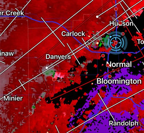
Bloomington. As we continued to monitor
radar, we saw a circulation develop to our
southwest near Danvers, Illinois.
We moved slightly west and lined ourselves up with
it and then watched it approach.
As
it got to us it gained some intensity.
The circulation tightened and a brief, narrow
funnel cloud appeared out of the middle of the
spin.

|

|
It did not last very long and gusted
out quickly. We followed the storm, but
the circulation weakened.
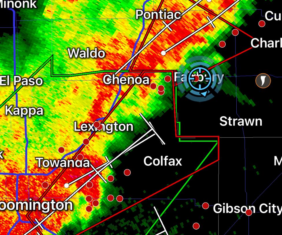
We continued to move northeast on Interstate
55 and exited at Highway 24 at Chenoa,
Illinois as the line of storms filled
in. Along the line, Many of the cells
now embedded in the line showed rotation and
became Tornado warned as they tracked
northeast.
We found
ourselves looking at the circulation in the
cell as it passed and then moved a little
further east on Highway 24 and would look at
the next circulation in the line.
Unfortunately, these cells would not reach the
intensity of the first cell that we observed
west of Bloomington. As the line filled
in further, the line became a huge
rain-maker. The last circulation we
encountered was completely wrapped in
rain. We saw the huge wall of rain
approaching as we moved in to intercept.
Regardless, we lined ourselves up with the
rain-wrapped circulation hoping near it, the
rain would lighten up for a view.
No such luck as once the rain and circulation
arrived, it was near zero visibility in the
heavy rain and we were forced to back out.
We eventually made it east to Interstate 57
for the drive back southward toward
home. The line of storms had now caught
up with us and we dealt with huge amounts of
rain, but we did keep our eyes on the radar
and made a play on a couple more embedded
circulations, all to no avail as the
circulations were short lived and weak.
To end the day, we were treated to a fat
rainbow as we finally broke free of the rain
and once we got to Interstate 70 moving
westward, we passed to the back side of the
line of storms and saw the very orange sunset.
As
a note of interest, we were in 5
different Tornado Warnings today.
Total Miles - 509
|
Click on
the link below to see video
of some of these storms.
|
 June 26, 2021