It
was very tempting to stay close to home as the
forecasters were calling for tornadoes right in
our the local region. The drawback would be
that the tornadic supercells would be embedded
within a line of storms ahead of a cold front
rather than the traditional, stand-alone supercell.
We certainly considered how much more
difficult it would be to predict, find, and
visually see a tornado with this type of storm.
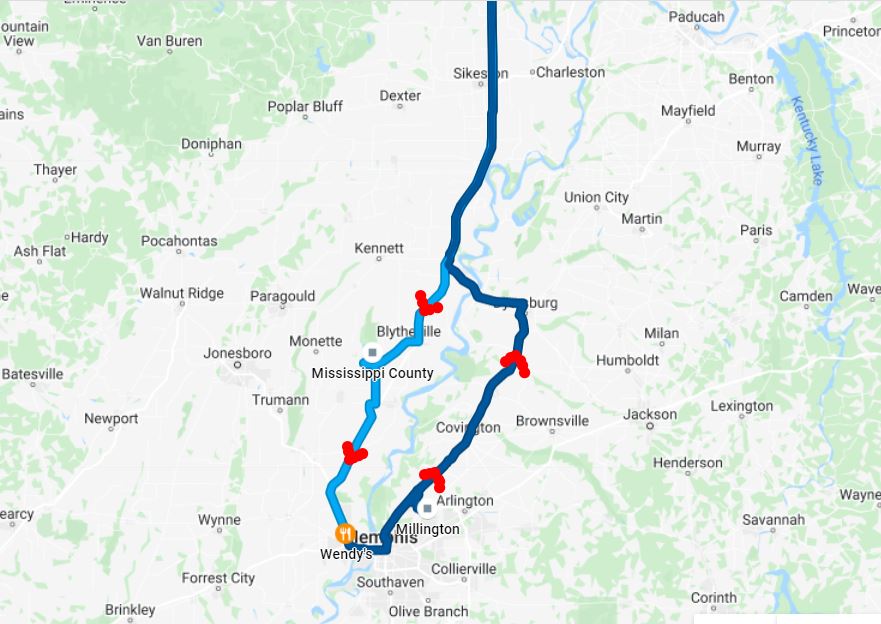
My
son Ryan joined me around 7:00am and we decided
rather than staying with the closer target, we
would travel down Interstate 55 to the
Missouri/Arkansas border as our preliminary target.
Down there, the possibility of having a discrete,
more traditional Supercell out in front of the
main line of storms was a much better probability.
As we drove south, we made a phone call to our
chase partner Brian Stertz (who was unable to
chase with us today) who confirmed our
decision to go south and advised us the better
parameters for discrete cells may be down closer
to Interstate 40 around the Memphis area.
Since
we arrived in Arkansas in mid-morning, it allowed
us a little time to do some wildlife exploring at a
local Northeast Arkansas Wildlife Area.
Birds and Snakes were the primary photo targets at
this spot.
After
an hour or so, we were back on the road down to
our target area down by Interstate 40.
A line of storms was out to the west, but to our
dismay, nothing was forming out ahead of the
line. Had some lunch and watched the line of
storms approach on radar. It became apparent
that no discrete storms were going to fire on the
Arkansas side of the Mississippi River, so we made
the decision to cross over into Tennessee holding
out some hope for the renegade storm out in front
of the charging line of storms. Now in
Tennessee, we took Highway 51 which went
north-northeast out of the Memphis area as we
stayed just ahead of the advancing storm
line. Several areas of weak rotation
prompted several Tornado Warnings in the line of
storms to our north, but rotation was not
sustained and threats were extremely short lived.
E
Eventually, a Tornado Warning was
issued along the line where we were. It
had a very minimal hook when it showed up on the
radar and disappeared as quick as it
showed up.
As the spot in the line that
prompted the warning came toward
us, it looked like a typical
gust front. As
it came over us, it was very electrical with
many cloud to ground lightning bolts at
close range.
 April 13, 2022


